United Kingdom
| Welcome |
| Peru in Brief |
| History |
| Geography |
| Government & Politics |
| Maritime delimitation between Peru and Chile |
| News |
Links |
| CUZCO | |||
 |
|||
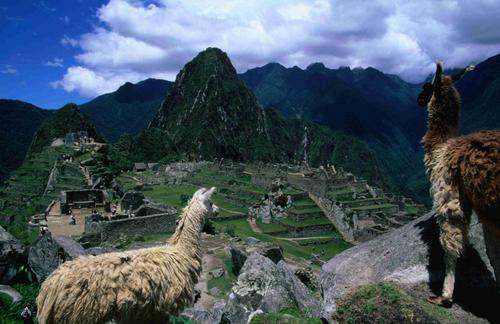
| Llamas in Machu Picchu | |||
| Capital: | Cuzco | ||
| Elevation: |
3400 m | ||
| Climate: |
Sunny during the day, cold at night (25°C to -3°C) | ||
| History: |
As the capital of the Inca or Tahuantisuyo empire. Cuzco was the heart of a political system that controlled a large portion of South America . After the Conquista. it was for some time the seat of colonial rule. |
||
Its original planners had conceived Cuzco as a major administrative and ceremonial centre. Accordingly, the city was erected on the slopes of a hill (the summit being reserved for the great fortress of Sacsayhuaman) and adopted the puma as its totemic symbol. The city limits were represented by two rivers; between these, the Incas built palaces, squares, streets and public buildings which have survived through the centuries to this day. |
|||
Following the Spanish conquest. Cuzco assumed a different though no less significant appearance. As churches and other major edifices were built, the new residents strived to show the best of their abilities. Indigenous and mestizo craftsmen not only innovated on European art by adding an American perspective; they created a distinctive new school for New World art – the Cuzco School of art and painting. |
|||
Cuzco thus witnessed the encounter between the European and native American civilisations. The cultural fusion and ethnic miscegenation that ensued from that encounter has had enormous consequences. |
|||
| Places of Interest: | ARCHAELOGICAL SITES: |
||
Machu Picchu. The citadel of Machu Picchu is Peru 's most important historic monument. Set between two peaks (one being the landmark Huayna Picchu ) at 2400 m elevation, near a precipice overlooking the swift bends and twists of the Urubamba river 400 metres below, the complex blends in stunningly well with its formidable surroundings. Even by modern standards, the Inca citadel is a powerful symbol of architectural skill. |
|||
The site's true name has faded away with time. Machu Picchu merely means "the old mountain", as opposed to Huayna Picchu , "the young mountain". Since its discovery in 1911 by the American explorer Hiram Bingham , the site has continued to baffle archaeologists, some of whose questions may remain forever unanswered. |
|||
Machu Picchu is divided into urban and farming areas, each quite distinct in architecture as well as function. Crops were grown on terraced fields connected by steps encased in the stone walls. The urban section revolves around a vast square on whose eastern and western flanks are two groups of buildings; these are linked to each other and to a series of smaller plazas and access points by a network of stairways totalling 3,000 steps. Water was distributed through a complex hydraulic system. Buildings are rectangular in shape, have only one level and share a common base plan. |
|||
The stone used for construction is mostly granite. Procured locally, blocks were cut by the Inca splitting technique and were probably sanded. It is quite likely, moreover, that walls had originally been plastered. The fact that the stones fit together so perfectly suggests that detailed studies were made to match concave and convex surfaces, as in a giant jigsaw puzzle. The flawlessness of construction at Machu Picchu is in fact so impressive that mythical explanations have been advanced to account for it. Experts agree, at any rate, that the site dates from the period (1438-1532) marking the height of Inca civilisation and power (itself the final manifestation in the 3,000-year sequence of Andean cultures). |
|||
Coricancha. A compound rising in the so-called Cuzco Wanka or mound of stones, this is a residential and religious site pertaining to the Kiliki culture which continued to be used for devotional purposes during the Quechua period |
|||
| Ajlla Huasi. House of the Maidens of the Sun ( Virgenes Escogidas ), Calle Inti Qijilo or Loreto. | |||
Amaru Cancha. Residence of the Inca Huayna Capac; the area is now partially occupied by the Jesuits' Church and the local courthouse and university. |
|||
| Kiswar Cancha. Residence of the Inca Viracocha; area occupied by the Cathedral. | |||
Colcanpata. The largest grain-storage facility in ancient Cuzco is located near the church of San Cristobal . |
|||
Cora Cora. Residence of the Inca Sinchi Roca; area occupied by the Portal de Carnes and adjacent buildings. Plaza de Armas. |
|||
Casana. Residence of the Inca Pachacutec; area occupied by the Portal de Panes and adjacent houses. Plaza de Armas. |
|||
Hatun Cancha. Residence of Tupac Inca Yupanqui; area occupied by the Portal de Belen and buildings on the Calle Triunfo . |
|||
Hatunrumiyoc. Residence of the Inca Roca and site of the famous twelve-cornered stone on the street bearing the same name. |
|||
| Puka Marka. Temple of the K-uichi (rainbow) in the area between Calle San Agustin and Calle Maruri Arequipa. | |||
| Suntur Wasi. The ancient seat of government; site now occupied by the Iglesia del Triunfo. | |||
Sacsayhuaman. The single most important Inca structure rises north of Cuzco proper. Designed by Pachacutec, the fortress was begun under Tupac Yupanqui and completed under Huayna Capac . Construction took 77 years and the effort of 30000 labourers. |
|||
| Ollantaytambo. An ancient fortified city 65 km NW of Cuzco. | |||
| Pisac. Situated in Coica province, the site features 4 sq Km of Incan ruins. | |||
| CHURCHES AND COLONIAL HOUSES <Click Here> | |||
| <BACK> | |||


