United Kingdom
| Welcome |
| Peru in Brief |
| History |
| Geography |
| Government & Politics |
| Maritime delimitation between Peru and Chile |
| News |
Links |
 |
 |
 |
 |
 |

| MADRE DE DIOS | |||
 |
|||
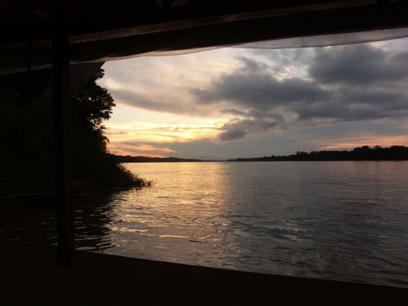
| Sunset at the Madre de Dios River | |||
| Capital: | Puerto Maldonado | ||
| Elevation: |
265 m | ||
| Climate: |
Tropical. | ||
| History: |
Very old sites such as those containing the petroglyphs along the Palotoa, Shinkebenia and Urubamba rivers indicate that human presence in this region preceded both the Conquista and the Inca empire. Archaeologists and anthropologists are also intrigued by the petroglyphs and other remains found around the headwaters of the Madre de Dios in the Cordillera de Pantiacolla. It appears that the area's earliest settlers, the Arahuacos or possibly the proto Arahuacos, migrated to Madre de Dios thousands of years ago and subsequently spawned the ethnic groups which eventually came into contact with the Incas and the Spaniards. The Machiguenga tribe still lives in Madre de Dios. |
||
Garcilaso reports in the Royal Commentaries that "King Inca Roca had resolved to send his son to conquer the Antisuyo. After advancing successfully to the Paucartambo river and having passed Challapampa and Pillcupata, the party continued on to Navisca and Tuno (Tono), heading for the valleys where the coca leaves are grown". We are also told about the Inca Yupanqui, who had sought to reach Mojo by way of the Amaru Mayo river but was forced to fight the natives and thus come all the way to the Benti. Later explorers include Juan Alvarez , who led a 250 man expedition into Madre de Dios in 1567, and Colonel Faustino Maldonado , who surveyed the region in 1861. |
|||
| Places of Interest: | Tambopata Candamo National Reserve. Covering 55 sq Km of pristine rainforest at the continence of the Tambopata and La Torre rivers, the reserve shelters approximately 600 species of birds. 900 species of butterflies and 115 species of dragonfly. |
||
Las Pampas Heath National Sanctuary. Created in 1983, this reserve measures only 109 hectares but is home to the celebrated "horsehair wolf”. |
|||
Manu Biosphere Reserve. Recognised by UNESCO in March 1973, the reserve extends over 18812 sq Km and comprises the fully-protected Manu national park (15,328 sq.km.), the tourist-oriented Manu reserve (2.57 sq.km.), and the Lower Manu , an inhabited area with great cultural significance (414 sq.km.). Scenic sites include lakes Valencia, Copa Manu, Zandoval, La Pastora, Tambopata, Madre de Dios, Cocococha, Tres Chimbadas, Amigos, and the rivers Manu, Tambopata, Madre de Dios, La Torre, Manuripe, Las Piedras, Tahuamanu. |
|||
| As an ecosystem that has evolved undisturbed for thousands of years, the reserve is one of the world's largest depositories of plant and animal life: it is believed to contain over 1000 species of birds and about 200 species of mammals in addition to 2000-3000 species of flowering plants, at least 10% of which probably are still unclassified. |
|||
| To enter the reserve a permit from the Manu national park authorities is required. |
|||
| Lake Valencia. Lying 60 km – four hours by motorboat – from Puerto Maldonado , the lake offers good fishing (bass, dorado, doncella). The trip down the Madre de Dios provides an opportunity to spot gold panners and admire a Huarayo settlement. The flora and fauna are impressive. |
|||
| The main indigenous groups are the Amaralari, Arasaeri, Kisambaeri, Pukirieri, Sapiteri. Toyoeri, Wachipaeri, Arawak, Machinguenga and Piro Mashko. |
|||
| <BACK> | |||